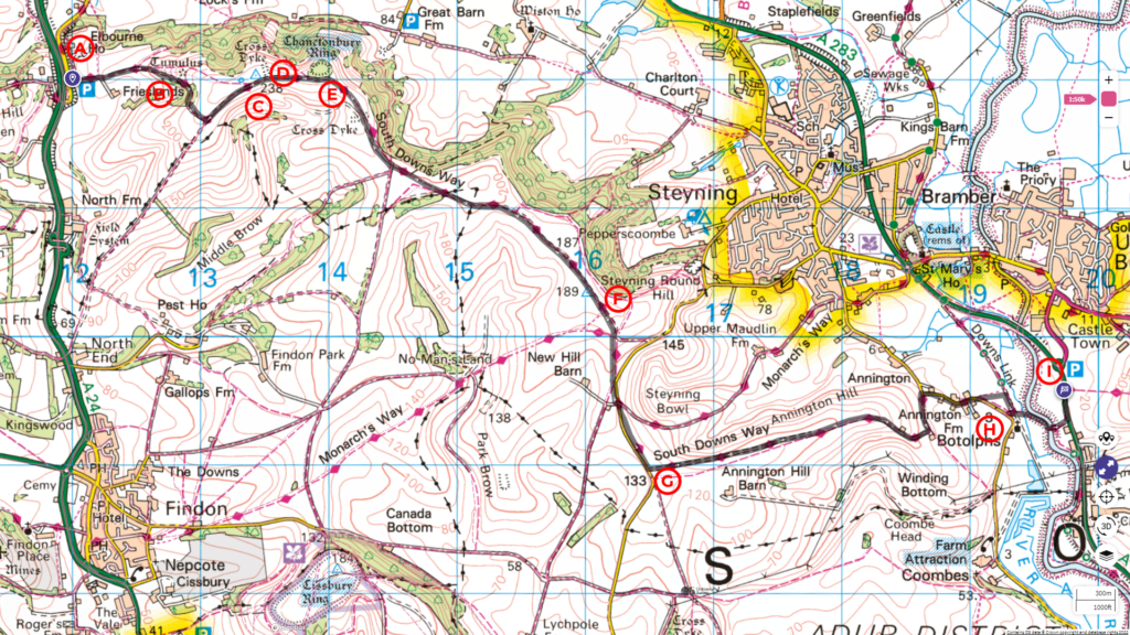
This journey will take us from the Wiston Estate Car park to Steyning, a distance of 10 km with an ascent of 148 m.
Follow the entire walk on . The route map is available on
.

Waypoints
A: Wiston Estate Car Park
B: Substation
C: Chonctonbury Hill
D: Ridgeway
E: Chonctonbury Ring
F: Four-way signpost
G: Pig farms of Annington Hill (not pleasant smelling)
H: Botolphs
I: Shoreham Road (A283)
Click here to our previous video and blog.
From the car park [A], we follow the sign for the SDW up to the hill. This steep climb rises about 130 metres in just over a kilometre. Be careful, as the chalk and gravel may have come loose along this path.
Take your time as you make your way up the SDW but look back occasionally to enjoy the scenic view of the valley as it falls away from you. And on a fine day, you may be further rewarded with recreational pilots flying by with warplanes from the last world war.
When you pass some electric substation [B], the SDW bears slightly right. A shortcut goes straight, but this will be steeper. In another 500 metres, the path levels out as the SDW meets another footpath from the right. Turn left and continue up the hill. The natural adventure
You soon reach Chonctonbury Hill [C] at 238 metres. Continue along a ridgeway [D] toward the Chonctonbury Ring, taking in the awe-inspiring vistas of valleys adorned with villages and towns. The rolling hills in the far distance serve as a backdrop.
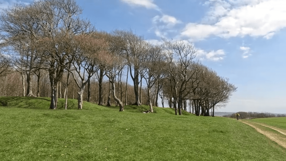
The Chonctonbury Ring [E] is a prehistoric hillfort that dates back to the Iron and Bronze age. It consists roughly of a circular low earthen rampart surrounded by a ditch. Take shelter in one of these low ditches from the wind that constantly blows over the ridgeway.
The SDW continues on the ridgeway to the next hill. Past out through a cattle gating, and the wide path trace the ridge, which has flattened out to flat pastures. The pastures are several hundred metres in width with grazing cows. The terrain remains like this for over two kilometres before the path arrives at a gate and becomes a track.
At this point, a four-way signpost [F] indicates the direction to Steyning 1.2 miles away to the left. Outside the gate, a small memorial stone structure marks the grave of Walter Longmead.
Our walk on the SDW now continues on the track toward Bostal Road, 300 metres away. As you walk, peer left to glimpse toward Steyning town in the distance.
At about 600 metres, the SDW turns left onto Annington Hill. Although it was mid-April, we walked head-on into a cold, howling, easterly wind. The path has become grassy alongside sheep pastures sheep on the left. Then, the scene changed as for the next 20 minutes, your walk would not be the most pleasant due to its proximity to a pig farm [G]. Undoubtedly, you will feel greatly relieved upon reaching the end of the farm, where the SDW once again become a wide gravel track. After it passes out through a gate, it becomes a narrower footpath. Follow this path bearing left at a fork. Continue straight until you reach Annington Road. At this point, turn right and follow the road into the village of Botolphs [H].
As you exit the village, the SDW footpath continues by the left side of the road, keeping you safe from traffic. Before long, you come to a stream that flows on your right and in another 200 metres, you will arrive at Shoreham Road (A283) [I]. Our walk end here.
Buriton to Steyning
Thank you for joining us on this final walk in our current series. The journey started from Bariton and covered a total distance of 57 kilometres over three days. Please check the blog and accompanying highlight video .
Our next series
We’ll take a short break before continuing our journey from the A283 toward the town of Eastbourne. This will cover a distance of about 68 kilometres. Please subscribe to our Youtube channel to stay notified when it happens.

