Walk serenely through a tropical rainforest, following the deserted rail track and the tranquil pools of an abandoned quarry, all while serenaded by melodious birdsong and the rhythmic buzz of cicadas.

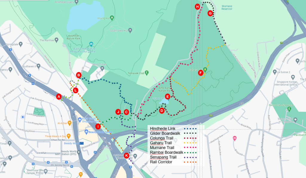
B: Hindhede entrance
C: Visitor pavilion
D: Quarry hut
E: Colunga view deck
F: Tree top bridge
G: Murnane reservoir and pipes
H: Murnane entrance
I: Beauty World shopping centre
J: Senapang Trail
K-L : Rail corridor
We explored the Rifle Range Nature Park and a portion of the Green Corridor. This nature park, spanning 66 hectares, opened in November 2022. It serves as a green buffer for the Bukit Timah Nature Reserve and nearby developments, offering over 7 kilometres of well-maintained trails and boardwalks. Our walk covered some of these trails, including a short section of the Rail Corridor, a former railway line now used for wildlife movement.
Our journey began on the [A] overhead bridge over Upper Bukit Timah Road during the morning rush hour. Bukit Timah Road, Singapore’s longest road, stretches from the CBD in the south to the causeway to Johor Bahru in the north.
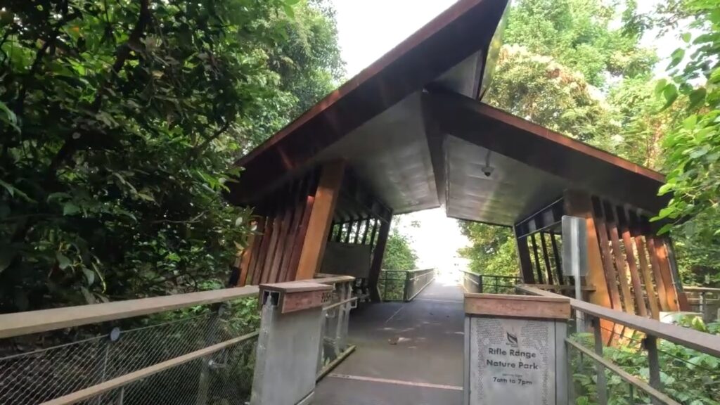
After crossing the bridge and passing under a subway, we continued on the road to the right. This road leads to the visitor centre of the Bukit Timah Nature Reserve, about 200 meters away. However, we turned right into the Hindhede entrance of the Rifle Range Nature Park. From there, we followed the [B] Hindhede Trail, which passes behind houses and leads to a stream before entering the forest. This trail, like all others in the nature park, is well-paved, maintained, and equipped with rope handrails. After around 500 meters, the trail transformed into a boardwalk, offering elevated views before reaching the spacious [C] Visitor Pavilion. You can explore exhibits here to learn about the park’s history and watch videos on its wildlife. (For those driving, this visitor centre on Rifle Range Road is a convenient starting point).
We climbed a few wide steps to the left to reach the roof level of the Pavilion. From there, we rejoined the boardwalk, which took us above Rifle Range Road. On the other side, the boardwalk became the Glider Broadwalk. After a short 100 meters, there was a forest exploration trail on the left, leading to a children’s play area before rejoining the boardwalk at the [D] Quarry Hut. This hut sits next to the Quarry Wetland, once the Sin Seng Granite Quarry, which used to be 55 meters deep, making it the deepest in Singapore. Today, it’s a serene wetland where you can spot marsh birds, including the white-throated kingfisher.
Continuing from the wetland, the boardwalk became the Calugo Trail, gently uphill and supported by steps and boulders. The Pan-Island Expressway, just 50 meters to the right, produced a distant hum. After about 400 meters, we reached the [E] Colunga view deck, offering a clear view of the Quarry Wetland below. The Malayan Colugo inspired the deck’s design in flight.
We doubled back and continued left along the Calugo Trail for 100 meters until we saw Rifle Range Road on the left. Turning right, we followed the Gaharu Trail. After 100 meters, the trail turned left onto a narrow path, leading downhill for about 300 meters before arriving at the [F] Tree Top Bridge. This bridge suspended 12 meters above the ground, spans 150 meters across the forest canopy, blending seamlessly with its surroundings.
From the other side of the bridge, we continued on the Gaharu Trail. After about 400 meters, we reached Jalan Kampong Chantek. Turning left, we walked along the road, with the nature park on the left and the [G] Murane Reservoir’s high fence on the right. The Murane Reservoir, named after David J. Murnane, was constructed in 1953 to provide a backup water supply to western Singapore. You can see the 39-inch pipe that brings water from Mount Gunong Pulai in Johore to Singapore.
At the end of Jalan Kampong Chantek, we followed the path right next to the fence, gently descending until it met Rifle Range Road at about 200 meters. Turning right, we followed the road briefly back to the Murnane Entrance of the Rifle Range Nature Park. From here, the Murnane Trail led us in a southwesterly direction. After about a kilometre, we arrived back at the Visitor Pavilion.
Continuing on the boardwalk at the roof level of the Visitor Pavilion towards the Rambai Boardwalk, we covered 200 meters to the Rambai Hut. Beyond the Rambai Hut, the boardwalk leads to an overpass over Jalan Anak Bukit, which takes you to [I] Beauty World Shopping Centre, a food and shopping mall.
Instead, we retraced our steps along the Rambai boardwalk, leaving before the Pavilion to join the [J] Senapang Trail. This trail led us to Rifle Range Road, where we turned left, passing under the Pan-Island Expressway supported by large concrete piers adorned with bird wildlife paintings. Near the piers is the [K] Rail Corridor. Turning left here, we headed northward along the corridor. In about 650 meters, we arrived near the [L] subway and the [A] overhead bridge, where we began our walk in the morning.
We hope you enjoy this walk as much as we did.

