Glad to have you back as we resume our journey along the Wey River, picking up where we left off at Ladymead in Guildford and heading towards Bowers Lock.
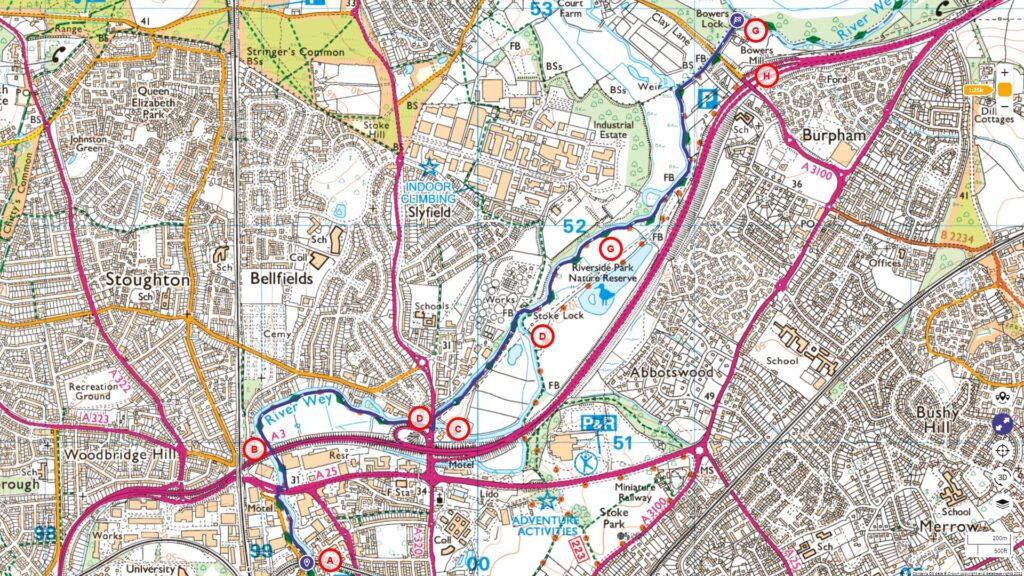
Follow the entire walk on . The route map is available on
.

A:Ladymead
B:A3 highway
C:Stoke Mill
D:Stoke Bridge
E:Stoke Lock
F:Riverside Park Nature Reserve
G:Bowers Lock
H:Bowers Mill House
I: Lock operation
Crossing the A25 at Ladymead [A] can be tricky, given its high traffic, so always ensure you cross carefully and strictly at the pedestrian lights. Once you’ve safely crossed, make a right turn to rejoin our scenic towpath, which now lies on the river’s right bank.
The pathway stretches forward, heading north. It soon passes underneath the massive A3 [B] highway. A few hundred meters after, it veers westward, presenting a sprawling open plain to your right. The northern riverbank here is adorned with picturesque homes, boasting gardens that spill onto the river, perfect for mooring boats.
Soon, we’ll approach Stoke Mill [C], a notable structure sitting beside the bustling A320, which serves as a conduit between Guildford and Woking. Constructed in 1879, Stoke Mill doesn’t boast the historical longevity that many of its peers along the Wey do. However, in its proximity was the site of the pioneering mill established by Weston in 1635.
The water route by Stoke Mill is particularly intriguing, marked by a leat, or a man-made watercourse, that diverges from the main river only to merge back after a brief meandering stretch. Over this course stands Stock Bridge [D], with a double span hovering over both the cut and the river.
As you transition from the towpath to Stoke Bridge, take a left to traverse this bridge, which spans both the leat and the bustling A320. Rejoining the towpath, you’ll sense a departure from the urban rush, even as the serene surroundings slowly give way to vast canopies of trees arching gracefully over the river. Yet, in the distance, the omnipresent roar of the A3 remains.
Our journey now brings us closer to Stoke Lock. Here, a flotilla of boats sits moored on the left. This lock holds historical significance as perhaps Surrey’s earliest pound lock and potentially even England’s first. It was ingeniously designed atop water meadows, aiding in meticulous water management, which in turn augmented hay yields by preserving ground warmth during frosts, enabling a dual harvest cycle.
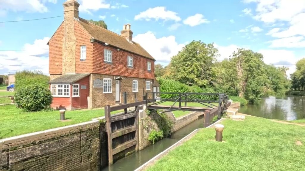
The existing Stoke Lock [E], inaugurated in 1653, features an imposing grey stone within its construct. This stone relic hails from Henry VIII’s erstwhile palace at Oatlands near Weybridge, which met its end in 1650. Given the exorbitant costs of building materials in those days, reusing materials, especially those as regal as Tudor bricks, was common practice. Adjacent to the lock is the lock-keeper’s dwelling, erected in 1882, which replaced an older structure. For context, this lock is situated 21 kilometers away from the Thames River.
Soon after the lock, a metal bridge guides us over the Wey, channeling the water previously diverted at Stock Mill. Following this bridge, nature enthusiasts are in for a treat with the Riverside Park Nature Reserve [F]. This expansive 30-hectare sanctuary houses an array of wildlife including birds, amphibians, and mammals. The reserve is a mosaic of habitats including broadleaf woodlands, a sizable lake, wetlands, scrublands, meadows, and ponds.
A further 500-meter walk introduces us to Bowers Lock [G], ensconced among mature trees. Its origin traces back to 1653. In its vicinity rests the Bowers Mill [H], now transformed into a private dwelling known as Bowers Mill House. Intriguingly, this mill was conceptualized by the Duke of Sutherland specifically as a laundry facility for Sutton Place. For further context, Bowers is situated 19 kilometers from the Thames.
As we near the video’s conclusion, witness a visual spectacle of two long boats adeptly navigating Bowers Lock, moving downstream [I] . This sequence provides a detailed overview of the locking process – from securely anchoring the boats, to the sluice gates being activated, permitting water inflow to modulate the water level, and culminating with the opening of the lower lock facilitating the boat’s exit. It’s noteworthy that Bowers Lock boasts a height exceeding 2 meters.
Looking ahead, we’re excited about our upcoming episodes which will explore the Wey Navigation’s stretch from Bowers to Weybridge, spanning 19 kilometers. For regular updates, ensure you subscribe to our channel.

