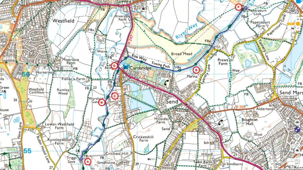
Take pleasure in a picturesque stroll along the breezy water meadows adjacent to the River Wey, tracing its historic path as it winds its way from Triggs to Papercourt Locks.
For the full walking experience, you can follow the entire route on , and the route map is available on
.

A: Triggs Lock
B: Worsfold Gate
C: Worsfold Gate Keeper’s Cottage
D: Cartbridge
E: Cartbridge Basin (Marina)
F: Papercourt Lock
Our previous section of the walk concluded at Triggs Lock [A]. In this video, we’ll continue our journey from Triggs Lock.
The low-lying terrain in this area was historically prone to frequent and severe flooding. In the 1930s, a portion of the meandering River Wey was rerouted to create a straighter path, which we’ll traverse for approximately 500 meters after leaving Triggs. Across the bank is the original meandering course of the river.
About 700 metres downstream from Triggs is Worsfold Gates [B] which play a crucial role in safeguarding the Wey against floods. Like all locks, sluice gates are installed here. These gates regulate the water level and boat passage by opening and closing them. At Worsfold Gates [B], these sluice gates are equipped with traditional-style wooden sluice rods, which are manipulated using a crowbar and secured in an upright position with pushing pins. These gates represent one of only two remaining examples of the original lock design developed by Sir Richard Weston, the builder of the Wey Navigation, in the mid-17th century. More.
The chamber between these gates retains its original turf sides and has a square shape. Typically, these gates remain open to allow boats to pass freely as the canal maintains a consistent water level in this section. They are only closed when necessary, especially during floods, to manage significant changes in water levels. When closed, they divert excess water into the river’s original course, leading north towards Old Woking, preventing potential flooding elsewhere. Once the threat subsides, floodwater gradually returns to the watercourse through sluices. The Navigation reconnects with the river just downstream of Papercourt Lock. Worsfold Gates are located about 14 kilometres from the Thames. More.
The lock-keeper’s cottage [C] at Worsfold Gates stands as a rare surviving example of an architectural style once common along the Navigation. Its simple appearance, marked by black weatherboarding, contrasts with the rustic timber and tile structure built around the same era. Nearby, a restored timber building, one of the oldest along the Navigation, is believed to have offered shelter to the navvies who worked on the cuts in the 1650s. More.
As you approach Cartbridge [D] in Send, you’ll find that the A247 (Sends Road/Broadmead Road) now passes over it.
Send has a rich history, with recorded mentions dating back to the Anglo-Saxons in 960 and inclusion in the Domesday Survey. In 1086, Send had a mill, a church, and fisheries. Use Cartbridge to cross to the other side, then pass under the bridge to continue along the north side. You will notice a date of 1759 under the bridge. The bridge was last rebuilt in 1914, apparently to a slightly different alignment to the original brick bridge. More
The towpath makes a sharp 90-degree turn flowing eastward. Just 100 meters north of the towpath (not visible), is the Broadmead cut, dug in the 1930s as part of a flood control system, managing water for both the navigation and the traditional meadows. These meadows were historically opened for public grazing after Lammas in August, following the hay harvest. Another 100 meters north of the cut lies the original, tightly meandering River Wey.
Continuing on the towpath, you’ll pass Cartbridge Basin, a marina and the offices of the Send Business Centre, on the right bank. In approximately 300 meters, you’ll arrive at Papercourt Lock [F].
Papercourt Lock has a rise of about 2 meters. While originally constructed in 1653, it has since been relocated by the National Trust to improve water management in the area. The lock is approximately 12 kilometres from the Thames River. Initially located closer to the lock-keeper’s cottage, it required manual management due to the absence of a self-regulating water control system. To address this, a tumbling bay was constructed to provide the necessary control. The lock-keeper’s cottage, an integral part of the lock’s history, was also moved and reconstructed in 1922, resulting in an interesting story about the lock-keeper’s strategic positioning for a clear view along the river.
Today, at Papercourt, you can savour the soothing sound of flowing water.
Feel free to hit that subscribe button on our YouTube channel, and stick around as we continue to head towards Weybridge!

